


|
Progress Report: November 6, 1999
Team Members:
William
B. Barr, MA (Project Director)
Cecile
Hollyfield, BFA (Director of the Celtic Legacy Foundation)
Scott
G. Sutton, MA (Archaeological Consultant)
Ben
B. Hollyfield (Field Technician)
Amanda
K. Saum, BA (Field Technician)
Written by Scott G. Sutton

November 6, 1999
With three hours of sleep, the crew headed to the
field under sunny skies. Upon arrival, Barr and Sutton began
survey work, taking shots of the masonry tower, the
"Christian chapel", and the stone wall running between
the two. Of particular interest, readings revealed similar elevations for the Roman
portion of the structure. Shots of the eastern wall
foundation and the eastern segment of the southern wall yielded elevations within 1/5 of
an inch. Also, the eastern corner foundations of the "Christian chapel"
produced readings within 2/100ths of an inch.
While Cecile Hollyfield took further photographs of the site, Saum
and Ben Hollyfield continued mapping the floor plan of the masonry
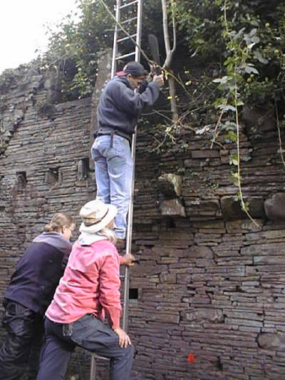
tower. In the afternoon, the team cleared the Roman walls of plant
growth which threatened the tower's integrity. From the hearth, Sutton chopped down two small trees that had toppled the lintel, and
the roots of which were displacing the hearth's lower masonry.
Once done, Barr, Saum, and Ben Hollyfield attacked an aggressive deciduous vine which had
overgrown the top of the wall. Their efforts cleared the northernmost window and much of the
remaining wall.
Before leaving the site, the team members reviewed their
observations regarding the structural evolution of the tower. The interior partition wall
jutting from the northern wall post-dates the Roman occupation. Not only does the
stone work qualitatively differ from the Roman portion, but it overlies linear floor stones that once
demarcated the same areas. These stones parallel but do not align with the existing
partition.
As to the Roman Period portion of the tower, the team noted a cement basing around the walls, likely added in the 20th century to
reinforce the walls' integrity. For analysis, Barr took mortar
samples from each of the distinguishable masonry styles. The Roman
Period stonework of the tower was constructed with a fine red clay mortar, while the medieval masonry utilized reddish-brown clay mortar with sand, shell,
and fiber tempering. Mortar from the 18th/19th century addition appear comprised of
a limestone base with fine twigs, straw, and small pebbles used for tempering.
In the afternoon, Cecile Hollyfield located a panoramic map that
shows an old Roman Road that appears to correspond with the one on site. To the
west, on the other side of the ridge, it extends in the direction of a Roman Period
trade center and interior port. This is the direction in which the road leads uphill
from the well. To the east, the road leads toward a circular medieval castle tower
approximately four miles to the east. According to the property owner, local lore
has it that the masonry tower on site was used to monitor and communicate with the castle
tower.
The crew continues to speculate on the original purpose of the
masonry tower. Obviously, the spring provides a convenient supply of water needed to
sustain a garrison. However, nestled against the hillside, the tower provides a poor
defensive position for repelling assaults from above. Situated at the convergence of
three valleys, the tower is strategically positioned. Although the tower does
provide a vantage point from which to monitor traffic in two of the valleys, these views
are not as comprehensive as might be provided by positioning further uphill. Perhaps
the Romans built the garrison to monitor activites at the well, a sacred Celtic
site. Or maybe they built here for reasons unseen by the modern eye. The overhang of a possible rockshelter protrudes from the hillside
directly behind the garrison. Before erosion buried the rockshelter, perhaps it
accessed underground deposits of salt or tin. The value of southeastern Wales as a
source of these resources is well documented, and a vast cave system has been recorded in
a neighboring county. It just may be that Llgadwy's Roman occupants mined the earth
below.
Note: These investigations are ongoing, and updates will
be posted as time permits. Assessments made during the course of this survey are
preliminary, and may change upon the recovery of further data.
|

