


THE EARTHQUAKE
OF 13 JANUARY 2001 IN EL SALVADOR
George Pararas-Carayannis
Introduction
On Saturday, 13 January 2001,
a powerful earthquake struck El Salvador in Central America.
This was the strongest earthquake to hit El Salvador since October
of 1986. The quake killed hundreds of people in San Salvador,
the capital, as well as in Las Colinas and other towns and villages.
Hundreds more were injured and thousands were left homeless.
Many people were trapped beneath the rubble of collapsed buildings.
Preliminary assessment shows that homes were destroyed beyond
repair while more are in need of repair. The greatest damage
to buildings, occurred in Las Salinas.
 As of January 15, 2001 preliminary reports
estimated that 2,000 were injured, 4,692 houses were destroyed
and 16,148 were damaged. The death toll has not yet been finalized.
Authorities estimate that more than 1,000 people are still missing.
Eighty-seven churches were damaged or destroyed - including Our
Lady of Guadalupe Church overlooking Las Colinas. These estimates
are expected to rise. No destructive tsunami was generated. As of January 15, 2001 preliminary reports
estimated that 2,000 were injured, 4,692 houses were destroyed
and 16,148 were damaged. The death toll has not yet been finalized.
Authorities estimate that more than 1,000 people are still missing.
Eighty-seven churches were damaged or destroyed - including Our
Lady of Guadalupe Church overlooking Las Colinas. These estimates
are expected to rise. No destructive tsunami was generated.
El Salvador, with geographic
coordinates of 13 50 N, 88 55 W is located in the Middle of Central
America, bordering the North Pacific Ocean, between Guatemala
 and Honduras on the CircumPacific Belt
of Fire, a region characterized by intense seismic and volcanic
activity. The capital of the country, San Salvador, is located
in a valley at 2100 feet (640 meters) on the eastern flank of
San Salvador Volcano about 20 miles (32 km) north of the coast
of the Pacific Ocean. Near the eastern end of the city is the
caldera of the Ilopango Volcano, now a deep lake. Due to the
threat of earthquakes, the city's houses tend to be low and surrounded
by open areas. and Honduras on the CircumPacific Belt
of Fire, a region characterized by intense seismic and volcanic
activity. The capital of the country, San Salvador, is located
in a valley at 2100 feet (640 meters) on the eastern flank of
San Salvador Volcano about 20 miles (32 km) north of the coast
of the Pacific Ocean. Near the eastern end of the city is the
caldera of the Ilopango Volcano, now a deep lake. Due to the
threat of earthquakes, the city's houses tend to be low and surrounded
by open areas.
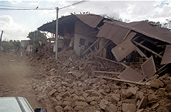
Church
destruction - Santa Ana


Earthquake
Epicenter, Origin Time, Magnitude and Aftershocks
Epicenter (USGS)
 The earthquake occurred at 17:33:29
UTC, Saturday, 13 January 2001. Its epicenter was at 12.83N,
88.79W, about 60 miles (100 km) SW of San Miguel and about 110
km SE of San Salvador, the capital. The quake's magnitude was
initially given as 7.6 on the Richter scale but later revised
to 7.9. The depth of focus was estimated to be 39 km. The earthquake occurred at 17:33:29
UTC, Saturday, 13 January 2001. Its epicenter was at 12.83N,
88.79W, about 60 miles (100 km) SW of San Miguel and about 110
km SE of San Salvador, the capital. The quake's magnitude was
initially given as 7.6 on the Richter scale but later revised
to 7.9. The depth of focus was estimated to be 39 km.
As of January 15, 2001, there
were 660 aftershocks, some of them quite strong. Most of the
aftershocks were centered within a few miles of the capital.
The largest aftershock, with magnitude 5.4, occurred late on
Sunday afternoon (14 January 2001), causing widespread panic
and forcing many residents of San Salvador to sleep in the streets
or in cars .
The quake was felt throughout
El Salvador with great intensity. It was also felt throughout
Central America from Northern Panama to Central Mexico - a distance
of more than 1,100 miles. In Mexico City buildings shook.
Recent Earthquakes
and Volcanic Activity in El Salvador
Earthquakes, ranging from
6.5 to 7.9 on the Richter scale, have struck San Salvador 13
times over the last 400 years, all but destroying the city in
1854, 1873, 1917 and, most recently, in October of 1986. The
1986 earthquake killed 1400 people, injured 21,000, and left
nearly 300,000 homeless.
Of the volcanoes located
within the metropolitan area, San Salvador Volcano last erupted
in 1917 and Ilopango Volcano last erupted in 1879.
Tectonic
Setting - Geological Instability of the Central American Region.
 The earthquake of 13 January 2001, occurred
on the Cocos tectonic plate, along one of the world's most intense
seismic zones where large destructive earthquakes occur with
frequency. The regional tectonic setting and seismogenic coupling
in this region are complex. The earthquake of 13 January 2001, occurred
on the Cocos tectonic plate, along one of the world's most intense
seismic zones where large destructive earthquakes occur with
frequency. The regional tectonic setting and seismogenic coupling
in this region are complex.
The geological instability
of this region, is caused by several tectonic interactions. The
Cocos tectonic plate is being subducted beneath two overriding
plates: the North America to the North-West and the Caribbean
to the South-East. Active subduction of the Cocos plate beneath
the Caribbean plate is responsible for the formation of the Middle
America Trench - which is the plate boundary.
 The amount of seismogenic coupling in
the region appears to be controlled by several other interacting
factors such as the age and motion rate of the subducting Cocos
plate, the width of the seismogenic layer, the rheology of the
overriding plate, and the influence of the nearby Motagua-Polochic
fault system. Segmentation of the subducting plate limits the
amount of seismic moment release and therefore the size of potential
earthquakes in the region. Therefore, maximum earthquake magnitudes
may not exceed 7.9 on the Richter scale. The amount of seismogenic coupling in
the region appears to be controlled by several other interacting
factors such as the age and motion rate of the subducting Cocos
plate, the width of the seismogenic layer, the rheology of the
overriding plate, and the influence of the nearby Motagua-Polochic
fault system. Segmentation of the subducting plate limits the
amount of seismic moment release and therefore the size of potential
earthquakes in the region. Therefore, maximum earthquake magnitudes
may not exceed 7.9 on the Richter scale.
As a result of active interaction
and movement of these tectonic plates, hundreds of earthquakes
of all sizes are recorded every year throughout this region.
Examples of recent large events in the region are the 7.9 magnitude
earthquake of 13 January 2001 in El Salvador, the February 4,
1976 earthquake (Ms 7.5) in Guatemala, and the October 1986 earthquake
in El Salvador.
The larger seismic activity
results primarily from the active subduction and collision of
the Cocos tectonic plate underneath the Caribbean plate. As a
result of this active interaction and tectonic plate convergence,
several depressions (horsts) and grabens have been also formed
on the landward direction of the Middle America Trench, paralleling
the Pacific coast. A chain of several active volcanoes have been
formed on land. Also secondary faults and other geological structures
are responsible for a number of earthquakes of moderate size
throughout this region.
A Tsunami
Was Not Generated
Although the earthquake of
13 January 2001 occurred along a subduction area known for its
tsunamigenic potential, the reason that a destructive tsunami
was not generated may be that the depth of focus of this particular
event was rather deep at 39 km. The focal depth and epicenter
location indicate that this earthquake was probably along the
Beniof Zone rather than along the subducting boundary where shallow
focus events cause large vertical displacements of the ocean
floor. As more seismic data becomes available, a source mechanism
study will be undertaken to determine why a significant tsunami
was not generated and to understand better the seismotectonic
coupling and tsunamigenesis of the Cocos tectonic plate in this
particular region of Central America.
RETURN TO
Visit

 The Next Great California Earthquake
(A new book by Dr. George P.C.)
© 2001 George Pararas-Carayannis
/ all rights reserved
The Next Great California Earthquake
(A new book by Dr. George P.C.)
© 2001 George Pararas-Carayannis
/ all rights reserved
|